John Marbut is an Aerspace Engineering student from Embry Riddle Aeronautical University (Prescott, AZ), who is currently participating in the UAS7 Study and Internship Program. Mr. Marbut applied for the UAS7 program in February 2015 and was selected for a Study Semester at Munich University of Applied Sciences (Wintersemester 2015/2016), as well as for a hands-on lab internship at Hochschule Bremen City University of Applied Sciences (Sommersemester 2016). We recently learned that John Marbut’s time in Germany had been spectacular and full of adventures so far since he has had the opportunity to join a research team from UAS Munich to Ecuador in November 2015. In the following blogpost John Marbut writes about his experiences in mapping the Ecuadorian rainforest.
Please note that the original blog post first appeared on the Student Blog from Embry Riddle Aeronautical university. We have John Marbut permission to publish his article on our blog: http://riddlenationaz.erau.edu/2016/02/02/john-marbut-mapping-the-equadorian-rainforest-with-uas/
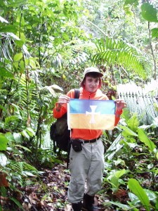
John Marbut in Ecuador (Image by Hochschule München)
I was lucky enough to get the opportunity to join a research team and senior thesis project at the Munich University of Applied Sciences, the major focus for the project was mapping the Ecuadorian rainforest. The group was actually invited to do the mapping through their partnership with Amazonica who works with the tribes to help improve their quality of life by improving education and providing medical supplies. The planned project required us to modify the UAV/Drone (it can fly autonomously or via remote control) from the last AUVSI competition. We needed to be able to get high resolution photos of the rainforest in order to be able to generate a 3-D map of the area we flew over, so the team installed a new payload containing more batteries, room for the camera, and an infrared trigger to start the camera. The antenna used to update the information about the drone’s had a range of about 5 miles, however the autopilot could fly without making contact with the homebase and the drone had a maximum flight time of just over an hour. The picture above is from our last flight in Shartamensa, home to some of the Achuar tribe.